Space is notoriously compact in Japan so we resigned ourselves to the idea of a double bed in at least some of our lodging, but in searching hotels and apartments online, I discovered a nasty little trick called the “semi-double” bed. The first time I came across this term, I’d clicked on a listing for a “double bed” room that seemed like a surprisingly good rate. Getting right down to the booking stage, I saw the phrase “semi-double.” This was new. The listing had only said “double.” Having no idea what the term meant–but feeling suspicious–I did a little research. Sure enough, a “semi-double” is basically somewhere between a single and a double or full bed in width (110-120 cm), i.e., a somewhat bigger single bed. A double bed is usually around 140 cm and a twin around 90 cm.
I came across this term over and over in Japan: Selling a beefed-up twin bed room to two people. And, often the semi-ness of the semi-double is not clearly specified until a later screen (and sometimes not at all–I call if in doubt). You’ve got to be kidding! I love my husband, but he’s a big guy and neither one of us would get much sleep with the two of us crammed into a bed that size. And, I can only imagine the size of the room that goes with these beds, too. It’s hard to picture where luggage for two people would go either. Anyway, be advised.
As David likes to describe it, after 15 days on a ship, we’re like a couple of baby birds kicked out of the nest when we land: What?! We have to figure out where to eat on our own?? Kind of pathetic. Despite the initial adjustment, we were more than ready for some time ashore on our own. Cruises are fun, but it was time to dig in a bit deeper.
We lucked into sunny skies our first day in Tokyo, the only real weather problem being a bit too much heat and a haze that made tower viewing of Mt. Fuji a nonstarter. We spent the first night onboard, so only baby steps required: taking a train from Shinagawa station (the station nearest the industrial port where the ship berthed the first night before moving to the nicer Yokohama cruise port). The ship shuttled us to Shinagawa, so all we had to do was catch a train to Tokyo Station. Easy, right?…Except for the total lack of English on the signage. Thankfully, helpful young ladies in uniform are stationed throughout area train stations and we were soon on our way.
Equestrians at the Imperial Palace gardens
After wandering the gardens of the Imperial Palace, we walked to Hama-Rikyu Park, a place I remembered mostly for its old duck hunting blinds…and the water bus to Asakusa, the real reason to go for me. For around $6 apiece, we caught the water bus for a 40-minute ride along the river to the charming old Asakusa district with its temples and narrow, crowded roads. The water bus has both an air conditioned interior and an open, covered interior deck (with tinted transparent roof, so you can see up). There’s also an air conditioned toilet. An audio guide is broadcast in both Japanese and English as you glide under bridge after bridge, taking in the changing cityscape; it really is one of the best deals in Tokyo.
Looking back at the water bus dock at Hama-Rikyu ParkOn the water bus
Asakusa is big fun. Lots of locals rent kimono to wander the old temples and vending stalls, adding much to the scenery themselves. I get a particular kick out of the young couples, out on a date in their traditional clothes, selfie-sticks at the ready and the family groups with everyone down to a toddler in the stroller decked out. We came upon two weddings: one bride in a gorgeous red kimono and the other in a traditional Shinto white kimono and headdress. David was shoulder-to-shoulder with the official photographer, but no one seemed to mind.
David’s fantastic photo of the happy couple
We joined a line for a small restaurant with no idea what they served. David confirmed the presence of air conditioning inside and it smelled good, so we went for it. We ended up with overpriced–an Asakusa hazard–tempura prawns with a large tempura bay shrimp patty in a bowl of rice with cold beer. The tempura suffered from a lid placed on top so that steam robbed it of crispness. Not great, but a pretty darned enjoyable break after much walking in the heat.
Lining up for lunch in AsakusaTempura lunch
After the technology and skyscrapers of modern Tokyo, Asakusa provides a wonderful contrast of Old Tokyo: temples and shrines, the smell of incense and street food, the flash of kimonos among the throngs, shaven-headed monks and rickshaw drivers running with amazing stamina. I wouldn’t miss it!
Our first full day truly off the boat with luggage in tow, we made our first travel error by hopping on a train going in the wrong direction. So much for my travel wiles! It’s not something I do often, but I’ve definitely done it before. Usually, I catch it sooner, though: It took me 30 minutes before I noticed we were getting more rural instead of the expected Tokyo skyline. A personal “best.” Aaargh. Oh well, easy enough to get on a train going the other direction; just an annoying waste of time and some extra schlepping of luggage. But, this was when I discovered a really great trick for navigating Tokyo trains, metro and bus: Google Maps combined with Google Translate. [Both require Internet connection (although there’s an offline option for Google Translate where you download a specific language; see below), so get a SIM card if you can. See my earlier post about NTT Docomo card. It’s been great for us.]
Google Maps will actually tell you the next train going to your destination, give you the platform number (a vital bit of info when nearly everything at hand is in Japanese), and count down until departure. If you miss that train, you can re-search for the next fastest departure and it will find other routes as well.
Unfortunately, we discovered in Kyoto that while much info provided by Google is in English, Google often gives you bus, bus stop names and other info in Japanese characters:
This is where Google Translate comes in handy: Take a screen shot. Open Google Translate [choose Japanese to English, of course] and tap on the camera icon. Instead of taking a photo now, select the little box with a mountain scene in the bottom. This will take you to your recent photos where you can choose the screenshot. Let Google Translate scan and find the Japanese writing. When it’s finished scanning, you’ll see the Japanese writing (and sometimes other words) in boxes:
Then, just scribble over the Japanese writing with your finger and Google Translate will translate the words you’ve chosen into something you can read:
You can use the same method with screen shots of locations on Google Maps.
We use Google Translate all the time when we travel. It’s not perfect, but it’s pretty amazing (and sometimes funny). Using the eye symbol feature (where available), you can translate live time. It’s like peering through a magic window into an English-language world wherever you are. It even preserves fonts in live-time. In Belgium, we’ve been able to look at a hand-written chalkboard menu in Dutch and see the translations, as if written in chalk in English. Wow. On our current Asia trip, we use the simple photo translate option for information plaques and the like. It was a huge help when I needed prescription eye drops in Kyoto and the pharmacist spoke no English. I could translate my needs by typing a couple of words in Google Translate on my phone (and pointing to my eye), then read the dosage information of the package by taking a photo in Google Translate.
You need an Internet connection to use Google Translate, unless you choose “offline translate” and download the language of your choice–a great feature.
Celebrity Millennium “Sweet 16” balcony, cabin 6030. The balcony of our neighbor to the right ended at the midpoint rib in the privacy wall.
The “Sweet Sixteen” cabins on Celebrity’s Millennium-class ships are a little-known anomaly: 8 cabins on each side of Deck 6 offer double-deep balconies for the same price as their otherwise-identical neighbors. For some reason, the Sweet Sixteen don’t appear on the deck plans (which depict the cabins as having shallow balconies just like the others on that deck). In researching our trans-Pacific cruise, I came across mention of these cabins and, since we booked very early, I found that nearly all of them were still available. (My booking agent had never heard of these cabins, but secured my preferred cabin.)
Close up of Deck 6 plan showing no difference in balcony size between the Sweet 16 and their neighbors
I deliberately chose the aft-most cabin on the starboard side, 6030, as I was curious about the view toward the stern and liked the idea that one of our neighboring balconies would be set back from our own. I liked my choice and we did have an extra element of privacy and a more open view sternward.
View toward the stern from balcony of 6030Sweet 16 cabin 6030 is just above the “C” in “Celebrity” with the other Sweet 16’s on starboard going to the right until just over the “E” in “Millennium”
While these cabins don’t come with lounge chairs, there is plenty of room for them and I did read of one cruiser who was able to have two delivered after tipping his steward. The primary negative of these balconies is that the people above you can look down on the front half of your balcony. I knew this going in, and it didn’t bother me at all, but it might be a consideration for some.
Looking up and toward the bow from the balcony of 6030. Shows “gap” in deck over the balconies above
All of the Sweet Sixteen balconies are not identical. The first 3 have thick support columns that run from 3 levels above to the front of their balconies and a full roof at that level above them. (The smaller balconies above these Sweet Sixteen are in a recessed, cave-like setting that wouldn’t be at all to my liking.) The lowest numbered of the Sweet Sixteen on the starboard side (6016) has a solid wall on the left as you look off the balcony, rather than the usual opaque privacy walls. The front half of our balcony and those of most of the remaining 6 cabins on each side are shaded by a deck overhang 4 stories above. (The back half of each balcony is shaded by the 3 levels of balconies immediately above.) However, cabin 6026 on starboard and cabin 6031 on the port side fall within a gap in the above deck and might get more sun (and less protection from rain).
Celebrity has four Millennium-class ships: Summit, Constellation, Infinity and Millennium.
My personal verdict on ship vs. plane when crossing an ocean: Boat may be way slower, but this is way better than any airplane seat I’ve ever had!
I’ve been on quite a few cruises over the years, but they’re the minority of my travels. Very occasionally we just want an easy getaway, but most often lately we use cruises as transport from one point to another. I’d eyed “repositioning” cruises with envy for years, but could never take advantage of them due to my sons’ school schedules. With my boys off on their own now and David and I both retired, I’m loving taking advantage of these seasonal moves of ships from one “theater of operation” to another. Prices on these cruises are usually much lower than comparably-long regional cruises. The lines are basically trying to make some money while relocating their ships. The trade-offs for the passengers are fewer ports and frequent time changes (albeit incremental–an hour a day or so–rather than the large time-changes you get with an overseas flight).
We meet lots of people who take repositioning cruises and then fly straight home, but for us they’re a way to launch travels on another continent. When it’s time to come home, we use miles and/or points to buy one-way tickets home. (While one-way plane tickets purchased with cash can be ludicrously expensive–often more than a roundtrip ticket–, most mileage programs allow one-way tickets at a simple and fair one-half of the roundtrip mileage cost.)
Not only are repositioning cruises one of the best travel values out there, they’re a great way, if you’ve got the time, to get somewhere far away, comfortably and with no jet-lag. A trans-ocean cruise can give you 2 weeks (or more) of room, board and entertainment for much less than a first class flight and sometimes for less than a business class flight. (Any cruise ship cabin is infinitely more comfortable than either a first or business class seat on a plane…and economy seats are hardly worth a mention in a discussion of “comfort.”) This is especially true if, like us, you don’t gamble, don’t drink much alcohol, don’t like soft drinks, don’t do the overpriced cruise excursions, aren’t tempted by “specialty” restaurants, spas, “duty free” shopping, onboard internet, or any of the other myriad ways cruise lines seek to pull more money out of you. For us, they’re primarily moving hotels where we enjoy our time alone together and meeting new people, reading and watching the water from our balcony, disconnected from the rest of the world for a while. We also plan our own time ashore. If you love all those cruise extras– and many do–your costs can be substantially higher. It’s a matter of choice and preference, of course, just be aware.
Cruise stops are, by their very nature, a quick peek at a location. Often no more than a classic “toe-touch”, say-I’ve-been-there, remain-in-a-protected-bubble kind of affair (usually a pet peeve of mine), they can be fun and they do have their place in my travel plans. The ports can be limited on a repositioning cruise, but we look at them as an added bonus. And, like Dutch Harbor, they can be unusual–and unusually remote–locations.
Visiting somewhere via cruise can also be a good option if it’s a place you’d like to see, but aren’t really sure you want to spend an extended amount of time there. Cruise ports of call also make for good reconnaissance; sometimes I find a place begs for a longer return visit. And, of course, if mobility is an issue, cruises can be perfect for people who would otherwise find their travel wings clipped.
“Sweet Sixteen” cabin balcony: Not on the deck plan, but twice the size for the same price as a regular balcony.
Anyway, since they’re not my focus, I don’t plan to do too much in the way of cruise reviews. I will share, though, if I come across a particularly good deal or interesting angle. E.g., see my review of the “Sweet Sixteen” cabins on Celebrity’s Millennium-class ships: double-large balconies that don’t appear on the ship deck plans and for which there’s no extra charge. Since we prefer to avoid cruise ship excursions and do things on our own or in smaller tours, I’ll also document port details if the port of call is one (like Dutch Harbor) for which I had trouble finding information, pre-trip, on one of the many cruise-focused web sites.
There are lots of web sites out there that offer cruises, but I find vacationstogo.com to be one of the best sites for exploring cruise options and I always start there. They often have the best prices, too, but if not…well, I can be bought!
I arranged a private guide in Hakodate through the Hakodate Goodwill Association. http://www.hakodategoodwill.com/indexeng.html The Association offers tours for up to 6 people on a pre-arranged basis for an unbelievable 3000 yen total ($29.41) plus any expenses of the guide which was explained to be a day-pass for the tram (600 yen or $5.88) and maybe some entrance fees, although those might be free for the guide. How could I resist?
A few weeks before our departure, I posted on our Cruise Critic roll call and 4 shipmates quickly jumped on this deal. In about a week, I got an email response to my online application to the Hakodate Goodwill Association from a local named Kensuke (“Ken”) who agreed to be our guide. He responded promptly to my few email questions about payment and again the day before we arrived in Hakodate to give me a weather forecast and assure me he would meet our shuttle bus from the ship.
When I’d asked him by email how we’d recognize him, he wrote back to say he was “a 5’7″ Japanese man with black hair and brown eyes” and would be holding a sign. (I’d been really grateful for that last, since the physical description did little to set him apart from the vast majority of his countrymen.) Anyway, I’d created a mental image of a slender man, dressed in typical Japanese business black-and-white. His emails indicated a pretty good command of English, but I knew Google Translate could have something to do with that.
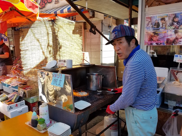
As promised, Ken was front and center, holding up a sign with my name as soon as we stepped off the shuttle bus from the port just after 11am. In contrast to my imagined guide, he was round-faced and a bit rumpled, wearing a black t-shirt with a large graphic design, and army green pants with a thick chain hanging from the wallet he kept in his pocket. It was also immediately apparent that his English was limited. Oh well, he was there and he knew where to take us, so all in all, things were OK. Ken walked us briskly into the nearby train station to buy day-passes for the tram saying we needed to hurry so that we could experience the morning fish market before it closed at noon. We pitched in 200 yen for his ticket, a whopping $1.96 per couple.
We walked the few blocks to the market where we found a teeming mass of activity. Hakodate is famous for squid. In the center of a big covered market, we watched people fishing for live squid in a tank to be summarily turned into sashimi. At Ken’s urging, David prepared to join the queue, but when 9 school kids piled in ahead of him, he changed his mind…and one squid got a temporary reprieve.
Fishing-for-squid tank in the Hakodate Morning MarketInspecting the goods
Ken’s English was limited, but it was great to have him identify some of the mysterious things for sale: whale bacon, smoked scallops (I’d thought they were caramel candies!), herring roe (the only item we didn’t like on our sushi lunch in Otaru–a strange, solid rubbery mass of tiny yellow beads) and so much more.
The covered market opened onto a busy, sunny street filled with vendors and tiny restaurants of all types. David bought a luscious slice of canteloupe, eating it perched on a bench beside his fellow customers. We bought “barbequed” scallops piled high on a shell and cooked on an open pit fired by a handheld propane torch until the broth around them boiled. Delicious! A little further on, I couldn’t resist squid ink soft serve ice cream that turned out to be surprisingly good…probably because there was little of the squid ink to be found other than the odd gray color.
“Barbequeing” scallopsDavid finishes off the last of the broth while the chef and his wife wait for the final thumbs-upSquid ink ice cream!
Leaving the market, we headed towards restored brick warehouses which Ken explained were now shopping malls. Their brick construction and the brick pavers we saw on roads belied the strong European influences in Hakodate. None of our group was interested in shopping, so we breezed past more music boxes and souvenirs, stopping only for cold local beers and a melon drink at a grocery store/deli.
Our path took us up an increasing slope to Higashi Honganji Temple, a beautiful Buddhist temple. After repeated destruction by fires, the current building was erected in 1915 and was the first reinforced concrete temple in Japan. Apparently, the construction caused some concern, both as to whether the material was strong enough to hold the massive roof…and as to the purity or lack thereof of a material that people had walked on and therefore made impure. Geishas were hired to dance on the floor and somehow that resolved all. The temple shows some western influence, one main depiction looking as much like a Catholic saint as anything. Nearby Catholic, Protestant and Russian Orthodox churches emphasize that influence.
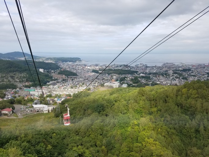
Continuing our uphill climb, we boarded the gondola up to the Mt. Hakodate Observatory House for a sweeping view of the city and the surrounding waters of the Tsugaru Straits. The Hakodate Ropeway (gondola) tickets turned out to be the biggest expense of the day at 1280 yen pp, roundtrip ($12.55). Sure enough, after a little negotiation between Ken and a lady at the ropeway office, Ken was free so long as we paid for the group of six at once. No problem. We were a cooperative group and we settled up quickly.
We finally used our tram tickets for a long ride to Goryokaku Fort, a star-shaped fort of European design. The grounds of the fort are now a park and people rowed small rental boats on the moat waters. At the center of the fort the former magistrate’s office has been rebuilt and provides an interesting glimpse of classic Japanese architecture. Tatami mats felt delightfully cool under my bare feet, giving off a fresh scent of straw. The large wooden sliding doors to the building were thrown open as well as the paper interior doors allowing in both sunshine and a light breeze from the beautiful day outside.
Pleasantly tired and happy after our long day and nearly 6 miles walking, I thought it a perfect end to our tour. The rest of the group agreed and we followed Ken to the tram for our ride back to the train station and the ship shuttle bus.
It was 4:45pm by the time we reached the station and Ken had had nothing to eat and only a few canned soft drinks despite our offers. We felt guilty that he was to receive only 3000 yen for nearly 6 hours of time with us. Conferring among ourselves and worried about the Japanese aversion to tips, we offered him an extra 3000 for his dinner which he very happily accepted. We parted with positive feelings all around.
I’d recommend the Hakodate Goodwill Association to anyone looking for an unbeatable deal, willing to try an amateur guide with unknown language skills, and physically able to handle a good deal of walking, often uphill. (We walked about 6 miles with Ken.)
______________________________________
Cruise port details:
It’s about a 15-minute shuttle bus ride from the port to the train station. There’s no realistic way to walk. Celebrity and/or the city provided the shuttle at no charge.
Free wi-fi was offered just beyond the gangway in the passenger welcome area.
I was totally charmed by Otaru. The old buildings of Sakaimachihondori Street, the main shopping area, are almost achingly picturesque…reminding me, in some ways, of a Japanese Carmel. We began our explore of the area at the Otaru Music Box Museum in a 3-story wooden building across from the towered post office. The “museum” is really more of a large souvenir shop selling every kind of music box imaginable. A tall clock outside the music box museum surprised us when it blew the half-hour on a train-like whistle, emitting a gray puff of smoke.
Otaru Music Box Museum
It’s an easy stroll from the music box museum down Sakaimachihondori Street toward Otaru Canal. Vendors on both sides of the street offer free samples: chocolate, sweet cakes and cookies, sake and other more exotic spirits like kelp “wine.” I found the seafood shops especially intriguing with all sorts of live and dead offerings, many of which I couldn’t identify. “Hairy crab” is a local specialty.
Sakaimachihondori Street
Kimono for sale just off Sakaimachihondori Street
At the end of Sakaimachihondori Street, we crossed a small canal and–after procuring some yen at the post office ATM–headed toward the main Otaru Canal and the sushi restaurant I’d booked for my birthday celebration. Otaru is famous for sushi and I wanted to be sure to get a seat at Mazasushi as it got great reviews, but I’d read that there were often long lines and that little English was spoken there. I booked through Savor Japan, the only service I could find that made booking in English in Otaru doable. https://savorjapan.com/ Although the maitre d’ had a little trouble finding the reservation, he did eventually locate it and we were seated at a window overlooking the canal across the street, just as I’d requested. Yay for Savor Japan! [There wasn’t a line, though, so we might have been alright without.]
Sushi lunch at Masazushi Zenan
The sushi was excellent and we had fun trying a new dish of squid, sea urchin and raw egg. To eat, we mixed the uni (sea urchin) into the raw egg, then dipped the squid in that. The “noodles” were cold and crunchy and made a really good accompaniment. I found the uni surprisingly mild, not at all fishy. This dish made me a convert.
We took a post-lunch stroll along the canal which is lined down one side with restored old warehouses. Otaru’s fortunes were built on the herring fishing industry before the fish left for different waters.
Otaru Canal
Leaving the canal, we walked a few blocks to the Otaru Train station to catch the #9 bus (220 yen pp one-way, about $2.15) to Mt. Tengu (Tenguyama) where we rode a gondola to the summit for a sweeping view of the city and harbor. A beautiful little meditation path leads past Shinto shrines through the woods to another overlook.
Mt. Tengu gondola
Mt. Tengu meditation path and Shinto shrine
The city bus picks up and drops off in the parking lot across from the base gondola station. There’s a glass shop across the parking lot with windows where we watched glass blowing going on in a downstairs workroom before catching the bus back to Canal Station. (You pay the driver via a machine when you exit the bus.)
On the bus from Mt. Tengu. I love the white gloves!
Because David always wants to try local beer, we made a quick stop at the Otaru “Brewery” and Restaurant which is really a German-style beer hall (kind of weird) with big brass beer tanks in the center of communal tables. The beer was nothing special, but we enjoyed sitting outside at a small table on the canal (which had the added benefit of letting us escape the pervading odor of smoked sausage inside–not exactly unpleasant, but we didn’t want to end up smelling the same way).
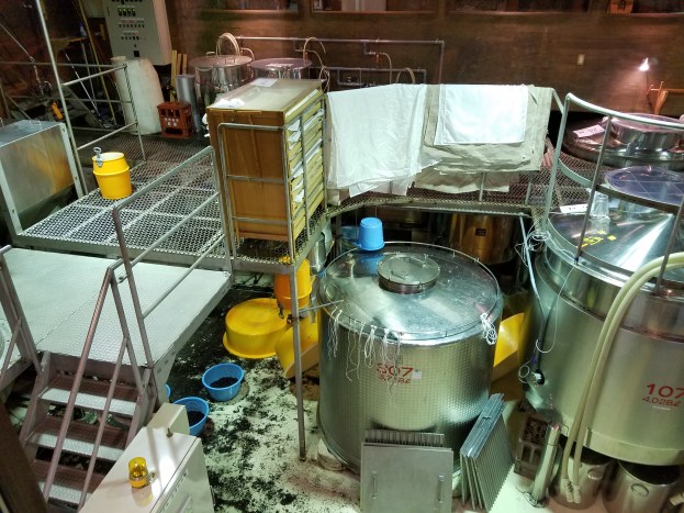
With David’s beer stop out of the way, it was time for my sake stop. The Tanaka Sake Brewery Kikkogura sits just north of the cruise port terminal so it made a convenient stop on our way back to the ship. A very friendly, giggling young woman poured 4 sakes and 3 fruit wines (blueberry, plum, and peach) for us to taste. Instructing us in the Japanese version of “Cheers!” she wrote out “KANPAI” to be sure we got it right. After purchasing a bottle of the really delicious plum wine, we toured the working brewery with the aid of an English self-tour handout. It was all very interesting and fun. Both the tasting and the tour are free.
Many little cups laterOverlooking the working part of Tanaka Sake Brewery Kikkogura
____________________________________
Cruise port details:
The city of Otaru set up information tables with maps and staff perfectly fluent in English.
Stalls selling food an souvenirs were also set up just off the ship.
A stall with free wi-fi was also provided.
It’s about a 20-minute walk from the ship to the Music Box Museum. It’s an easy walk with no hills, but several intersections. It’s not particularly scenic, but seemed perfectly safe. The guest information people were happy to mark the route on our map and point out ATM machines, points of interest, etc.
I’m posting onboard ship in the port of Otaru using a Japanese data SIM card I bought on eBay before leaving the U.S. I bought 2 of these cards which are by the Japanese company, Docomo, which my research showed to have the best coverage in Japan. The cards are for 8 days each, so we plan to use them back-to-back during our stay in Japan, using my Galaxy S7 phone as a hotspot for David’s Galaxy S7s and our laptop. Each card is described as “4G LTE, 3GB/8 days, unlimited.” The cards cannot be used with HTC, Blackberry, dual SIM phones or any smartphones made in China.
Approaching Otaru, Japan, this morning
The card starting working in the wee hours this morning, while we were at sea off the Japanese coast, but still some hours from the port of Otaru. The signal is strong and fast and both David’s Galaxy S7 Android phone and the laptop are connecting well with my phone’s hotspot.
I paid $26.98 for both cards, including shipping from Hong Kong. It took about 20 days for the cards to arrive, which was within the vendor’s estimated shipping time. He was very responsive to my questions and had good reviews, so I felt reasonably comfortable making the purchase. We might could have bought the cards in Japan and I read that visitor SIM cards are sold at Narita Airport. But, we are arriving by ship in Otaru where I could find no information about such SIMs and, even if we did find them, I had concerns about language issues. I also didn’t want to spend my limited time ashore looking for and waiting in a shop anyway if I didn’t have to. Given the reasonable price on eBay, it seemed a no-brainer to me.
I chose data-only SIM cards because we don’t really care about making calls–and should we need to, we can usually call for free using Google. The Internet, i.e., data, is what we really want and need for Google Maps, researching local sites, texting with home via WhatsApp, email, etc. Anyway, so far, so good!
UPDATE: I’ve been using the Docomo card for four days now and am generally happy. Sometimes, the connection is a little slow, but for the most part it’s been really good. Also, some of the sluggishness may be due to being offshore and to having other devices using my phone as a hotspot. Most impressive of all, not only did I retain connection when we were on a ship 15 miles off the Japanese coast, but I was even able to make a 30+ minute call to my son in the U.S. on WhatsApp with excellent quality…and for free!
The first stop on our trans-Pacific Vancouver-to-Tokyo cruise was Dutch Harbor, Alaska, in the Aleutian Islands. Dutch Harbor was a substitute stop, replacing the originally-scheduled Petropavlosk, Russia, on the Kamchatka Peninsula. I’d been really looking forward to the remote Russian stop and, while I was disappointed to miss the Kamchatka, Dutch Harbor was a happy surprise for me, personally. My grandfather (my father’s father) had been stationed there in WWII as a Navy dentist. My dad still has a scrapbook of his father’s from that time and I’d taken a photo of every page, eager to see if I could find anything recognizable in this remote port.
Dutch Harbor turned out to be a hit on all fronts for us. The only downside was that sunrise came an hour later than the day before so that, although we docked at 7am and David and I were ready to disembark at 7:30am, it remained pitch black outside. Hmm. Somehow we’d missed the captain’s notice that sunrise would come at 8:28am that day. So, we twiddled our thumbs until first light, then headed out for our planned hike up nearby Mt. Ballyhoo to the ruins of Fort Schwatka.
The local chamber of commerce had set up a table just outside the gangway with maps and other information. Unfortunately, they had forgotten the land use permits which we were told to buy ($6pp) before hiking any of the local trails. Someone had gone to fetch the permits, but the lady in charge told us to go on and, if stopped, just say they didn’t have them yet and could we pay whomever stopped us. Sounded good to us, so we headed off. (No one did stop us, so the hiking was free.)
Wellused map of Unalaska/Dutch Harbor provided by local chamber of commerce. Cruise port is at top right.
Before we even left the parking lot by the ship dock, we spotted our first bald eagle perched on the rocky mountain face opposite the ship. This boded well for our wildlife spotting! Sure enough, we saw many more during the day and someone likened them to pigeons in other cities. There are even signs in Dutch Harbor and Unalaska warning of eagle attack if you venture too close to nests! That was a new one.
The road to Fort Schwatka lay a short distance to our right as we walked out of the cruise port. The road is gravel and well-maintained, but a fairly steep 9° uphill via several switchbacks. All in all we spent 3 hours hiking up the mountain and around the old ruins, with a distance of about 6.5 miles. The views are spectacular at the top and we lucked into pretty good weather, although clouds snagged on the very top of the fort ruins and we got some drizzle. All the old wooden buildings have collapsed and no structure was identifiable as the places in my grandfather’s photos I carried on my phone. We could place some rock formations, though, and everything about the terrain looked the same. The old bunkers, dug a surprising way into the stone mountain, are still mostly intact and open for exploring.
The appearance of a red fox was extra fun as we wandered the ruins. He seemed more curious than afraid of us and actually seemed to wait at one point for us to catch up. Then, he ducked behind a bush and ended up behind us, continuing to follow for a bit. What a great encounter! (…and fun to see that my grandfather had a photo of a similar encounter. It seems foxes in Dutch Harbor have long been used to having humans around.)
As we headed back down Mt. Ballyhoo, we spotted a whale feeding in the harbor and a nearby group of twenty or so otters floating on their backs. Smaller water birds abounded as well. With the fresh, crisp air and the smell of wildflowers, it was a beautiful hike.
We had to pass back by the ship to continue our explore of Dutch Harbor and Unalaska, so we ducked in for a quick early lunch. Since Dutch Harbor is a commercial port, not really a tourist destination, the only transport were local school buses and vans the town dedicated to the cruise ship until the schoolchildren needed to be picked up and 12 taxis that serve the local population. We had to laugh when we learned that the buses took everyone to the Dutch Harbor Safeway grocery store. So much for exotic cruise locales! A guide on the bus announced they were going on to the old Russian Orthodox church in Unalaska. When we saw the huge double line of people waiting at Safeway for the bus, we opted to stay on and ride to the church. [Nomenclature is a little confusing. “Dutch Harbor” is the name the military and locals use for the whole area. There’s a Dutch Harbor post office near the Safeway and an Unalaska post office across the Captain’s Harbor bridge on the Russian church side of things. Technically, though, both sides are in the town of Unalaska.]
Long lines of cruise passengers waiting for schoolbuses in the Safeway parking lot
My grandfather visited this church back in the 1940’s and little appeared to have changed since then. I got a kick out of getting my photo taken there as he and a friend had.
Then, we wandered back down what passes for the main street of Unalaska (lots of small, ramshackle houses, the modest courthouse, and a restaurant) before taking a detour across a footbridge spanning a small river. There, we got a great view of salmon spawning as bald eagles glided above. A perfect mini-Alaska vacation!
Salmon spawning in Unalaska river
Salmon spawning near Russian Orthodox church
Across the bridge and to the left is the Unalaska Public Library where we’d been told free, if slow, wi-fi was available. True to billing, we managed to connect momentarily, but most sites resulted in the dread spinning donut of death. Oh well, the world could no doubt manage without us. Phone service was actually reasonably good, though, with my regular AT&T service, and I was able to get a call out to my parents and one to my older son who’d returned from an Iceland/Norway trip after our departure and from whom I was dying to hear details. Voices were clear although we were cut off several times.
We decided to walk back across a large bridge spanning Captain’s Harbor to Safeway. Bunker Hill loomed across the road to our left with clear, shallow water full of starfish in the harbor to our right. We saw two more eagles nesting on Bunker Hill while another glided nearby. We’d been lucky with the weather, but wind began to pick up as we reached the coast at the base of Bunker Hill. The temperature reached a delightful 56F. [Online weather forecasts I’d scanned prior to leaving home showed rain to be nearly a daily possibility in Dutch Harbor, and even my grandfather’s old letters and postcards spoke of the rain, snow, howling wind and even earthquakes.]
Starfish in Captain’s Harbor
Walking the long curve of coastline until we were just across from the Safeway, we reached huge stacks of crab pots interspersed with a series of WWII bunkers. Just beyond is a local bar/restaurant called Norvegian Rat Saloon. Dutch Harbor is featured in the popular show, “Deadliest Catch” and we were eager to try fresh king crab while here which we’d heard the Norvegian Rat prepared. However, the cruise director had warned that on the only previous stop the ship had made here, the lines were long and the crab sold out early. Of course, that had probably been at lunch and here we were mid-afternoon. We found a nearly empty parking lot and not a line in sight. We assumed the crab was long-gone, but seeing good beer on draft (always a draw for David), we couldn’t resist. When a tablemate from the ship informed us that a fresh batch of red king crab was being prepared, we happily placed our order. Ten minutes later, we tucked into a plate of crab, simply cooked and served with nothing but drawn butter. Absolutely perfect! [I’ll review the Norvegian Rat Saloon separately.]
Crab pots
Unfortunately, our break at the Norvegian Rat Saloon left us with too little time to comfortably visit the small World War II Visitor Center which lay between us and the ship. I really regret missing it as I had some questions about my grandfather’s photographs, but something had to give and I’m hoping to contact them when we get back home. If it comes down to seeing the museum or the actual locations, I’m glad we made the choices we did. It’s the nature of cruise stops to be left wishing for a longer stay. I’d say “Next time!”, but that seems unlikely: A local told us Dutch Harbor is a 2-3 hour, $1000 flight from Anchorage in a small plane through often-turbulent skies.
______________________
Cruise port details:
Ships dock on the “Dutch Harbor” side of the town of Unalaska, 1.3 miles north of the airport and the WWII visitors center. The area is industrial.
Free shuttles via 4 local school buses and a few vans to the Safeway were provided by Celebrity. Later buses extended their route to the Russian church. The buses and vans pick up on the dock a short distance from the gangway. Although the ship docked at 7am, buses were not available until 10am. Two of the four school buses stopped running at 2:30pm as they were needed to pick up school children. Vans continued to shuttle passengers.
There is no handicap-friendly transport for wheelchairs, etc. available on the island so you have to be able to negotiate the few stairs of a school bus or van.
12 taxis (some of which are vans) are the total sum of cabs in Dutch Harbor. A couple were waiting in the dark when we docked.
Our hike up Mt. Ballyhoo and back to the ship was about 6.5 miles. We walked approximately another 3.5 miles on our ramble from the Russian Orthodox Church back to Safeway.
There are no sidewalks in Dutch Harbor and we were warned to stay on the shoulder of roads (mostly paved and in good shape) and be alert. Most of the traffic is pick-up trucks and larger commercial trucks.
Lots of “Deadliest Catch” t-shirts, sweatshirts, etc. and other souvenirs are for sale in the store next to Safeway by the red-roofed Aleutian Hotel and in Safeway itself.
I spent nearly two weeks in Croatia with my sons years ago and the place I’d always regretted missing was Plitvice National Park. As far as I was concerned, Plitvice was #1 on my list for this Croatian vacation with David and now, as our trip neared an end, we were finally going to be there…and it was storming. Not just light rain, but a downpour. Aaargh!
The weather in Zadar had been overcast with occasional drizzle, but cleared to sunny the morning we set out on the drive to Plitvice. It’s an easy 2-hour drive from Zadar to Plitvice and the scenery is beautiful as you head into the mountains and cross over impressive bridges spanning wide inlets of water.
As we climbed higher into seriously rugged mountains, the weather began to deteriorate.
When we exited the truly impressive Sveti Rok tunnel (over 3.5 miles long!), wind buffeted our car to the point I was getting a little nervous despite the excellent, wide highway. Thankfully traffic was light. By the time we neared Plitvice Jezera, the skies had opened up and we pulled into the parking lot of our AirBnB apartment in the driving rain. Our lovely hostess awaited us in raincoat and hood and we left our luggage to dash inside, umbrellas held high.
Despite that inauspicious beginning, the next day dawned bright and clear and all we could have hoped for for our day at Plitvice. I was as excited as a child!
We got an early start, planning to park at the Hotel Bellevue near Entrance 2 to the park and avoid the less-convenient, paid parking designated for the park. As we turned in a guard stopped our car, asking where we were going. I just looked bemused and answered we were going to the Hotel Bellevue, of course, and he waved us in. Instead of turning left into the main hotel parking, we drove to the end of the short street and parked, near the pedestrian path into the park. This put us not far from a ticket office and park bus stop #2 (“ST2” on the map below). Perfect!
Our AirBnB hostess, Jelena, was a font of knowledge and she’d given us a park map and laid out an optimum walk for us. We followed all her suggestions and could not have been happier. Day tickets to the park were 110 kuna apiece (about $17 each). We caught the park bus (included in our tickets) heading toward Entrance 1 and got off at the bus stop #1 (“ST1” on the map below) to walk along the water (on our left) to view the largest waterfall Veliki Slap (literally “Big Waterfall”) on the far bank.
Park map posted near Entrance 2 ticket building/bus stop
The path to the waterfall itself was closed, for which I was just as glad. I was happy with the view from the opposite bank and, once I saw the scattered nature of Veliki Slap and a building at the summit of the waterfall, I was even less interested in going. I’m a waterfall junkie of sorts and have been to the top of lots of waterfalls, but I was fine with missing the top of this one. Maybe it was just me. Anyway, there was so much I wanted to see in the lower lakes and we headed back to continue the route Jelena had recommended.
An early view of Veliki Slap
We hiked down to the water, making our way along the water (now on our right) and past another four wide waterfalls before crossing over to the far bank where Jelena had told us to catch a boat at P3 (also included in our tickets).
View of wide waterfall from above
At water levelCrossing the waterBoat approaching the dockOff the bow of the boat
We got off the boat at P2 (see map above) and began an amazing wander through seemingly-endless waterfalls.
We spent several hours hiking the park. We found it to be a moderate hike, with occasional steep stretches and some dirt paths getting narrow and muddy from the previous day’s rain. Plitvice Lakes National Park is so large that we never felt crowded and while we did see other people (and there was a fair-sized Asian tour group at the boat stop) we also had plenty of space to take in the incredible, tranquil beauty of the park.
We ended our hike at bus stop 3 (“ST3” on the map above) where we caught the bus back to ST2 where we began our day. From there, we walked the short distance back to the national restaurant “Poljana” for lunch. It’s located just by the Hotel Bellevue with lovely views of the park. Unfortunately, we found both the food and service to be inferior to its sister national restaurant, Licka Kuca, near Entrance 1.
You can check out our 2-bedroom/1-bath AirBnB apartment at: https://www.airbnb.com/rooms/4699728?sug=50 At $75/night and a 10-minute walk to the park (in good weather), it’s a deal worth considering, especially so if you need two bedrooms.
If you’re new to AirBnB and want to give it a try on this or any other apartment, you can use my referral link which should get both of us $30 in AirBnB travel credit: http://www.airbnb.com/c/tcuthrell Let me know if you have any questions.


 Unfortunately, we discovered in Kyoto that while much info provided by Google is in English, Google often gives you bus, bus stop names and other info in Japanese characters: